Satellite networks
Majority of GPS trackers utilize GPRS connection for communication and data transfer.
GPRS networks seem like a good and optimal choice - it is very common, typically not expensive and there is a variety of providers to choose from. Widespread network nodes allow almost instantaneous connection and data transfer anywhere from low to densely populated areas.
However, GPRS does not cover 100% of the globe. There are countries with poor coverage. Zones affected by war or natural disasters can experience connection losses for days at a time.
Similar difficulties arise at sea or on geographical poles.
This is where a satellite connection can come in handy. In this article we will look into satellite connections used for phone and internet, their history and current applications.
Brief history of satellite networks
First ever artificial satellite was launched by Soviet Union in 1957 - Sputnik 1.
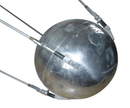
It was a metal ball, 58.5 cm (23 in) in diameter with 4 external antennas. Signals emitted by its 1-watt radio transmission unit could be received by any amateur radio enthusiast within 2000km range.
This launch marked the beginning of the Space age and prompted development of satellite networks.
Early communication satellites worked in passive mode - simply reflecting the signal from the source to the receiver.
This resulted in the end signal being extremely weak as most energy was lost.
Active relay communication satellites came to almost completely replace passive ones.
Unlike their predecessors, they amplify the signal before retransmitting it to the ground station. Project SCORE was the first active relay satellite. It operated for 8 hours, delivering Eisenhower’s Christmas speech to the world.
As the progress went on and future prospects of satellite communication became clearer, commercial applications were becoming more and more feasible.
In 1962 the first ever commercial communications satellite was launched. Telstar 1, built by Bell Labs, achieved transatlantic transmission of television signals.
By this time satellites were placed into medium or low earth orbit.
They had a high orbital speed and therefore they could not remain visible from any given point on earth. Instead, they appeared to move across the sky and disappear.

Such behaviour presented issues for continued service as any system required a large amount of satellites to stay connected. This issue could be combated by using geostationary orbits.
Syncom 3 became the first ever geostationary satellite. It was placed into orbit in 1964 and was used to transmit live coverage of Japan’s summer olympics to the US.
Success of satellite radio and TV didn’t go unnoticed.
First commercial satellite phone communication systems were started in the mid 70s.
They were being developed as an alternative to cellular systems that at the time were very bulky and expensive.
By the time the first commercial satellite network launched - GPRS and cellular phones had already progressed enough to be cheap and widely available.
Now, satellite phone and internet systems are more commonly used for applications like disaster relief, military communication, aviation and marine communications, and connection of remote areas.
As of 1 January 2021, there are 2,224 communications satellites in Earth orbit.
How do satellite networks work
Any satellite network typically contains 3 main components:
Satellites
Ground stations
Terminals (handsets)
Typically, when making a connection through a satellite network, your handset would connect to the satellite first. In turn, the satellite will pass the signal to the ground station for further routing.
Advanced satellite networks can also hand-off the connection between each other to maintain it or even pass the signal without the use of the ground stations.
Satellites can be places into several orbits, based on the distance from Earth.
When it comes to phone and internet networks, they typically can be split into 2 types based on their orbit:
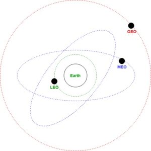
High geostationary orbit (GEO), 35,786 kilometres (22,236 mi) above the Earth
Low earth orbit (LEO), 640 to 1120 kilometers (400 to 700 miles) above the Earth
First types can provide near-continuous global coverage with a much lower number of satellites: only 3-4, where LEO can require anywhere from 40 to 70 units to operate. While this keeps launch cost low, GEO satellites themselves are very heavy and therefore are more difficult and expensive to build and launch than their LEO analogues.
LEO satellites provide lower latency but also lower bandwidth, maxing out at roughly 2-9 kbit/s, compared to 60-512 kbit/s provided by geostationary satellites. Network speeds are being improved as technology progresses.
Another disadvantage of geostationary systems is that they can only be used at lower altitudes - approximately between 70 degrees north and 70 degrees south of the equator. Hills, mountains and dense forests can act as an obstacle for the signal. LEO satellites do not have these issues as there are several satellites passing by at any point.
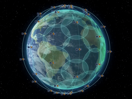
LEO satellites are not affixed to any point on Earth, companies need to ensure service is not dropped. For this reason, LEO satellites are typically connected into a Satellite constellation, some with possibility of inter-satellite communication. Within the network satellites are typically split into orbital planes.
Satellite vs GPRS
While GPRS progressed satellite phones and terminals didn’t stand in one place.
Today, some terminals can be no different in size than an average smartphone. Comparing with cellular networks, satellites provide following advantages
Better network coverage
Encrypted data transfer
Signal is unaffected by weather conditions
Network coverage is the main advantage. Not bound by ground cell towers, satellite systems can be used for remote deployments, aviation and marine applications, disaster relief and more, connecting even the most distant of teams.
Applications for leisure and science are not uncommon as well. Whether you are hiking in the mountains or are a part of a polar expedition - satellite connection will help you stay in touch.
There are no perfect systems, and satellites also come with a set of disadvantages, main ones being:
Higher prices for hardware and services
Lower connection speeds
Inability to switch between networks
Network operation costs are higher for satellites, hence the increased rates from operators. However, rental plans are also available.
Handsets are typically built and sold for usage with a certain provider and cannot be edited to connect to a different network. In addition to that, handsets themselves might be hard to come by due to local laws and restrictions.
Current satellite systems
Iridium satellite system

Iridium project started in 1988.
Network was planned to have 77 satellites and was named after a chemical element with the same atomic number - Iridium. Later it was discovered that only 66 cross-linked Low Earth Orbit (LEO) satellites would be enough to provide full coverage across the globe, including oceans, airways and polar regions.
System was developed with financial help from Motorola and the first ever test call was completed in 1997. Commercial network became fully operational on November 1st, 1998.
Original satellites’ lifespan was planned to be 8 years, however they continued to operate until they were replaced by improved Iridium-NEXT satellites. Improved system was deployed between 2017 and 2019 by the SpaceX company.
Iridium satellites have a cross-linked mesh infrastructure allowing them to pass signals between each
other improving continuity of service. Satellites communicate with each other via Ka band inter-satellite links. Each can have up to four inter-satellite links: typically two connections to neighbors in the same orbital plane, and two to satellites in neighboring planes to either side.
Iridium also utilizes ground stations which link to the network through the satellites visible to them. Currently there are 4 stations: 2 in the USA, 1 in Europe and 1 in South America. Iridium ground stations interconnect the satellite network with land-based fixed or wireless infrastructures worldwide to improve availability.
However, calls from one satellite phone to another can also be routed directly through space without going through a ground station.
The constellation of 66 active satellites has six orbital planes spaced 30° apart, with 11 satellites in each plane (not counting spares).
At the moment Iridium is the biggest commercially available satellite constellation.
Inmarsat satellite system

Inmarsat is a British satellite telecommunications company.
Company originated from the International Maritime Satellite Organization (INMARSAT) that was created in 1979 in order to establish and operate a satellite communications network for the United nations maritime community.
In 1999 the company was privatized and it’s operational unit was separated to become the UK-based company Inmarsat Ltd.
Inmarsat was the first privatized international satellite organization.
Whenever you make a connection to Inmarsat, your terminal will connect to the satellite first. Then, the satellite will transfer data to one of the ground stations to be delivered to the destination.
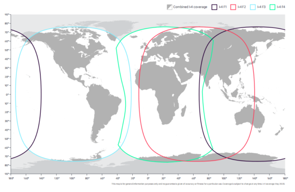
Unlike Iridium, Inmarsat utilizes 14 geostationary satellites.
Satellites belong to different series and are used for different purposes:
4 Inmarsat-3 satellites
2 used for backups
1 for existing services (operating through earth stations, not owned by Inmarsat)
1 is leased
4 Inmarsat-4 satellites
Used for Broadband Global Area Network on land.
5 Inmarsat-5 (GX) satellites
Used for Global Xpress - global service of up to 50 Mbit/s downlink and 5 Mbit/s uplink
Satellites are controlled from the Satellite Control Centre (SCC) at Inmarsat HQ in London,
which is responsible for keeping the satellites in position and for ensuring the onboard systems are fully functional at all times.
Common application for Inmarsat systems are:
Aviation (safety communications, on-board wi-fi for passengers)
Maritime communications (fishing vessels, off-shore rigs, passenger vehicles)
Government and military applications
Enterprise solutions for business owners
Inmarsat coverage
Inmarsat also provides global maritime distress and safety services (GMDSS) to ships and aircraft at no charge, as a public service.
Thuraya satellite system
Established in 1997, Thuraya is the UAE’s first home grown satellite operator.
Even though, company’s satellite network is small - just 2 geostationary satellites - it offers services in 161 countries in Europe, Asia, Africa and Australia.
First satellite is located in geosynchronous orbit at 44° E longitude, inclined at 6.3 degrees. Second satellite is orbiting at 98.5° E longitude, inclined at 6.2 degrees. Both satellites can handle up to 13750 calls at a time.
There are plans to launch a third satellite in the future.

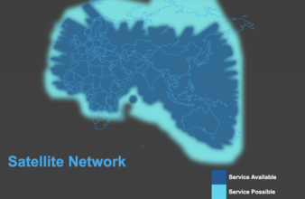
Thuraya coverage
Thuraya offers various communication services - calls, SMS and data plans. Company also produces their own handsets, most complete with GPS connectivity. Handsets can provide speeds of 60 kbit/s downlink and 15 kbit/s uplink. When using their own terminal ThurayaIP, speeds can reach 444 kbit/s.
Thuraya also offers a lot fo flexibility. Their SIM cards will work in regular phones, furthermore, regular SIM cards can be used for Thuraya connections, as long as GSM provider has a roaming agreement with the company.
Starlink

Starlink is an up and coming satellite internet constellation developed by SpaceX.
Constellation is planned to have thousands of satellites in low earth orbit.
As of May 2021 there are more than 1600 satellites deployed and operational. Around 32 ground stations are planned to be installed.
Unlike Iridium, Inmarsat and Thuraya - Starlink will not be connecting directly to the user’s handset. Instead users are supposed to obtain specific terminals that will have dedicated antennas to track satellites.
Network is still in Beta stage, with services available in just 8 countries in North America, Europe and Oceania. Early tests reported download speeds from 11 Mbit/s to 60 Mbit/s, and upload speeds from 5 Mbit/s to 18 Mbit/s.
Military and Aviation tests are still underway.
Once this network is fully operational, it’s extensive net of satellites will be able to provide internet connection across the whole globe and serve about 10% of total internet traffic.
Orbcomm

Orbcomm is an American company that offers industrial M2M and IoT communications hardware.
Projects started in late 80s, with the network design test satellites launching in 1992.
In 1995 first tests of global communications network were performed.
In February 1996, ORBCOMM initiated the world's first commercial service for global mobile data communications provided by LEO satellites.
Between 1997 and 1999 Orbcomm launched 33 more satellites.
As of 2021, company owns and operates a global network of 31 Low Earth orbit (LEO) communications satellites. Their accompanying ground infrastructure includes 16 gateway Earth stations (GESs) around the world.
Orbcomm services are available in more than 130 countries around the world.
Satellite support in hardware devices
Generally each satellite provider produces their own terminals, handsets and so on.
However, it's not unusual for unaffiliated companies to also support a certain system. Satellite data providers typically have an extensive network of partners to choose from.
Using satellite connections with Navixy
Navixy platform supports several trackers with Iridium/Inmarsat connection.
Galileosky v4.0 with Iridium module
Galileosky Base Block Iridium
Globalstar SmartOne
Globalstar SmartOne C
Globalstar SmartOne Solar
Naviset GT-10
Naviset GT-20
Orbcomm IDP-782
Teltonika FM63XY (via TSM-232 modem)
Teltonika FMB630 (via TSM-232 modem)
Teltonika FMB640 (via TSM-232 modem)